
Typhoon “#KikoPH” (CHANTHU)
Issued at 5:00 AM, 09 September 2021
Valid for broadcast until the next bulletin at 11:00 AM today
TYPHOON “KIKO” RESUMES ITS INTENSIFICATION OVER THE PHILIPPINE SEA EAST OF CENTRAL LUZON
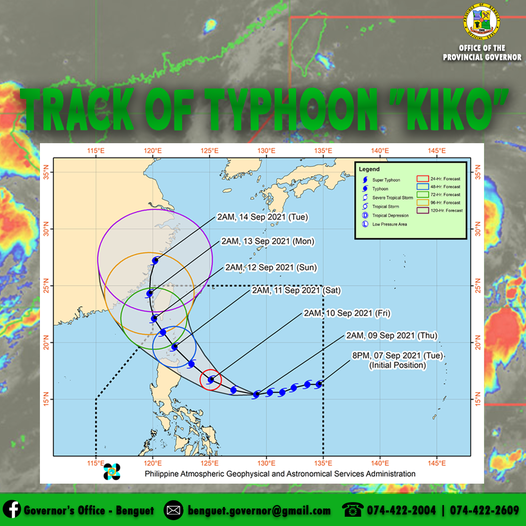
• Location of Center (4:00 AM)The center of the eye of Typhoon “KIKO” was located based on all available data at 785 km East of Baler, Aurora (15.5°N, 128.9°E)
• IntensityMaximum sustained winds of 185 km/h near the center, gustiness of up to 230 km/h, and central pressure of 935 hPa
• Present MovementWestward at 20 km/h
• Extent of Tropical Cyclone WindsStrong winds or higher extend outwards up to 180 km from the center
TROPICAL CYCLONE WIND SIGNALS IN EFFECT
• TCWS No. 1(Strong winds prevailing or expected within 36 hours)\
LUZON:The eastern portion of Cagayan (Buguey, Lal-Lo, Santa Teresita, Gonzaga, Santa Ana, Gattaran, Baggao, Peñablanca) and the northeastern portion of Isabela (Maconacon, Divilacan, San Pablo, Cabagan, Palanan)
HAZARDS AFFECTING LAND AREAS
Heavy Rainfall
• Beginning tomorrow evening, heavy to intense with at times torrential rains due to the typhoon may be experienced over Cagayan including Babuyan Islands, and northern Isabela. Moderate to heavy with at times intense rains may also be experienced over Batanes and the rest of Isabela.
• Under these conditions, scattered to widespread flooding (including flash floods) and rain-induced landslides are possible especially in areas that are highly or very highly susceptible to these hazard as identified in hazard maps.
Severe Winds
• Winds reaching strong breeze to near gale in strength (i.e, strong winds) with occasional gusts will be experienced within 36 hours within the areas where Tropical Cyclone Wind Signal (TCWS) #1 is in effect. This may result to up to very light damage to structures and vegetation. However, it must be noted that as the typhoon progresses towards Extreme Northern Luzon, higher wind signals will be hoisted in some localities within Northern Luzon.
• Based on the latest track and intensity forecast, TCWS #4 remains the highest wind signal that will be hoisted for this typhoon.Coastal Inundation
• Due to the strength of this typhoon, coastal inundation associated with high waves near the coast and storm surge may affect several coastal municipalities in Northern Luzon. The public and disaster managers, especially those in localities of Northern Luzon are advised to monitor for updates.
HAZARDS AFFECTING COASTAL WATERS
• In the next 24 hours, moderate to very rough seas (1.5 to 2.8 m) initially and becoming rough to very rough seas (2.5 to 5.0 m) will prevail over the eastern seaboard of Northern Luzon. Sea travel is risky for most sea vessels over these waters. Mariners without the proper experience should immediately seek safe harbor. Due to the strength of this tropical cyclone, sea condition over the aforementioned waters will further worsen tomorrow, making sea travel risky for all types of seacrafts.
• Moderate to rough seas (1.2 to 2.8 m) will be experienced over the northern seaboard of Northern Luzon and the eastern seaboards of Central and Southern Luzon. Mariners of small seacrafts are advised to take precautionary measures when venturing out to sea. Inexperienced mariners should avoid navigating in these conditions.
TRACK AND INTENSITY OUTLOOK
• Typhoon “KIKO” is forecast to move west northwestward or northwestward today through Saturday, with periods of short-term wobbling in its movement. On the forecast track, the typhoon is forecast to pass very close to northeastern Cagayan and cross the vicinity of Babuyan Islands between tomorrow afternoon and Saturday early morning. The typhoon will then pass to the south and west of Batanes between Saturday early morning and Saturday afternoon.
• Given the recent southward shift in the track forecasts of “KIKO” from the previous bulletins, the possibility of landfall over mainland Cagayan is not yet ruled out. As such, the public is advised to continue monitoring for possible changes in the track forecast in the succeeding bulletins.
• After traversing the Babuyan Islands and Luzon Strait, the typhoon is forecast turn north northwestward and northward on Sunday through Monday morning as it passes near the southwest and west coasts of Taiwan and move over the Taiwan Strait. For the remainder of Monday through Tuesday morning, “KIKO” will turn north northeastward and make landfall in the vicinity of southeastern China.
• KIKO” is forecast to continue intensifying and may reach a peak intensity between 185 and 205 km/h tomorrow evening while passing close to mainland northern Luzon and over the Babuyan Islands. Weakening is forecast to begin by Sunday as the typhoon passes close to and begins to interact with the rugged terrain of Taiwan.
Considering these developments, the public and disaster risk reduction and management offices concerned are advised to take all necessary measures to protect life and property. Persons living in areas identified to be highly or very highly susceptible to these hazards are advised to follow evacuation and other instructions from local officials. For heavy rainfall warnings, thunderstorm/rainfall advisories, and other severe weather information specific to your area, please monitor products issued by your local PAGASA Regional Services Division.
The next tropical cyclone bulletin will be issued at 11:00 AM today.
DOST-PAGASA